I just realized it has been 4 years since I posted any hiking adventures. Little did I know then, that my hiking days would be very limited to none at all in the coming years. I am now focussing my adventures on seeing the beauty the State of Oregon has to offer. Just in a different way.
I first attempted to explore the Crooked River National Grassland on Monday May 18th, 2020. It rained for 15 hours and the area was completely muddy and wet. I abandoned that exploration and moved on to somewhere less wet.
I returned to the grassland 10 days later on May 28th. I was greeted with sunny dry weather. Well, until Saturday the 30th. A series of storms moved through the state. Oddly, the Willamette Valley and Portland had more lightning than Central Oregon. But we were not left out of the fun. The storm raged through for an hour. Lightning and high winds. Even hail. I learned of a lot of damage in the town of Culver, just 5 miles from where I was camped out. I even witnessed a small forest fire start in the distance, which was under control by the next morning.
The first few nights I camped in my van near the Haystack Reservoir. I need to stay within cell phone range due to health issues. The view was awesome. The Grasslands are used by off road vehicles. These areas tend to be a bit littered. It wasn't too bad where I was staying. There were very few people in the area. It was very peaceful. Lots of birds and coyotes off in the distance. At times it was breezy. But warm.
Sunday, the day after the storm, I chose to explore a little. I went into an area outside of Terrebonne along the Deschutes river. It is BLM land, so camping would be free. I pulled up and saw some amazing views of the river and nearby mountains. But the area is next to a busy road. I took a quick nap and moved back to the Grasslands. Which are federal public lands. Free camping too :)
I drove around a bit in the grasslands and found a spot on a ridge top that had amazing views. I was about 1 mile from where I was the previous days. There is a horse camp nearby and horse trail skimmed by my stopping point. I chose to camp here for the night. With plans on leaving the next day. Monday June 1st. The views are spectacular. I could have stayed another day or two. But I will return in the future. Very quiet and only a few people here and there.
When I arrived at my final camp spot, I was greeted by a gentlemen riding a horse. The hood of my van was up. He made his way off the horse trail to check on me to see if I needed any help. I immediately laughed and explained to him why my hood was up. The prior camp spot, I heard what I thought was a woodpecker in the distance. My bad ears heard wrong. The sound was coming from inside my engine compartment. I had popped the hood to look in and a
pack rat was staring at me. Just as frightened as I was. It scrambled away and I dropped the hood. I immediately looked up on the internet of how to keep them from coming inside my engine area. I learned they are trying to get 'supplies' for their nest elsewhere. Supplies meaning, wire coverings and such. They can cause a lot of damage and make a vehicle inoperable. I also learned that keeping the hood up and putting a light in the engine area at night keeps them away. So I did that in my final camp spot and no woodpecker sounds that night :)
I woke the next morning. Monday June 1st. What I saw was breathtaking. The view was amazing. The sunrising through some low clouds to my east. Mt Jefferson to my west was lit up as if God was shining a spot light on her. I quickly took some photos and made a cup of coffee. I sat and took in all that was around me. I took my time making breakfast. Then lunch. Slowly organized and slowly explored some more area in the Grassland on my way back home.
 |
| First camp site. As I ate lunch, a Osprey flew a mile from the lake to join me. That is a fish on the right side top of the pole. |
 |
| Sunset my first night. |
 |
| Rock formations all around. |
 |
| Olallie Butte. North of Mt Jefferson. South of Mt Hood. |
 |
| Haystack Butte. Haystack Reservoir is just to the right of it. |
 |
My Osprey friend returned to have breakfast with me.
He must have been full from the night before. He had no fish this time. |
 |
| Sunset my second night. |
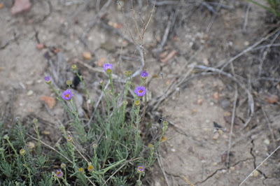 |
| Desert Flowers. There were many. |
 |
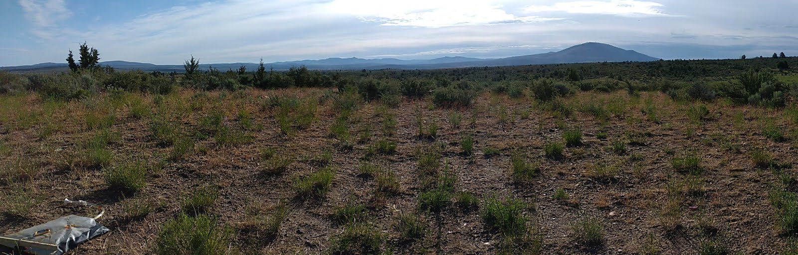
Now I know why the area is called Crooked River National Grassland.
There are grass growing all over. |
 |
The storm approaching on Saturday.
The dark area on the bottom left just above the trees is dust blowing in from the desert.
The white thing is my cell phone antenna. |
 |
After the storm moved through, a lightning strike started a fire near the Metolius River.
Which flows into Lake Billy Chinook. It was under control the next day. |
 |
| Mt Jefferson blanketed in clouds after the storm moved through. |
 |
| A helicopter seemed to be evaluating the power lines after the storm the next day. |
 |
| The morning after the storm, Mt Jefferson awoken. |
 |
The spot where the cowboy on a horse approached me. And my camp spot for the night.
That is a water tower on its side. Lots of the area is used for cattle grazing. |
 |
| A meadow just below the ridge I was camped out on my last night. |
 |
| Sunset with Olallie Butte in the foreground. |
 |
| God shining is spotlight on Mt Jefferson my last morning. |
 |
| My last morning view to the west. |
 |
My last morning view to the east.
|
 |
| The two spots I camped. |


No comments:
Post a Comment